


Praça Salles Filho
Rota do trem, da pesca e dos grandes rios-LIVE CAM
6.4K subscribers
No Website Available
Santa Fé do Sul, São Paulo, Brazil

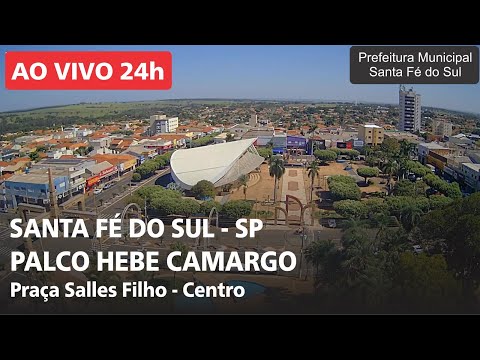
This live webcam offers a panoramic view of Praça Salles Filho in Santa Fé do Sul, São Paulo, Brazil, capturing the vibrant heart of this riverside city. The camera, positioned atop the main church tower, showcases the expansive square adorned with well-maintained green spaces and palm trees. At its center stands the Palco Hebe Camargo, a modern stage named in honor of the iconic Brazilian television personality, which frequently hosts cultural events and public celebrations. Adjacent to the square is the Igreja São João Batista, a historic parish church that anchors the community's spiritual life. Notably, the intersection features a monument with an obelisk and four porticos, commemorating the city's 60th anniversary and depicting panels that narrate Santa Fé do Sul's history from its founding to the present day.
Santa Fé do Sul, São Paulo, Brazil

Santa Fé do Sul is a municipality in the state of São Paulo, Brazil. It is located in the southeastern part of the state, approximately 470 kilometers from the city of São Paulo. The municipality has a population of around 22,000 inhabitants.
The city is situated on the banks of the Grande River, which forms the border between São Paulo and Minas Gerais states. Santa Fé do Sul is part of the Mesoregion of São Paulo and the Microregion of São José do Rio Preto. The city's economy is primarily based on agriculture, livestock, and services.
Santa Fé do Sul has a total area of 1,608.7 square kilometers and an elevation of 570 meters above sea level. The city's climate is characterized as humid subtropical, with high temperatures and significant rainfall during the summer months. The region is known for its fertile soil and favorable climate for farming.
The municipality is served by several major highways, including the BR-153 and SP-310. Santa Fé do Sul has a relatively small urban area, with basic infrastructure and services, including healthcare, education, and transportation. The city's cultural and historical heritage is relatively modest, with a few notable landmarks and events.
