Hula Nature Reserve
Charter Group Birdcams ציפורים אונליין קבוצת צ'רטר
254K subscribers
Yesud HaMaala, Northern District, Israel

Hula Nature Reserve
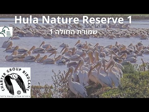
This live webcam offers a tranquil view of the Hula Nature Reserve in northern Israel, a vital wetland habitat nestled in the Hula Valley. Once drained in the 1950s, this area has been restored and now serves as a crucial stopover for migratory birds traveling between Europe, Asia, and Africa. The reserve's marshes and open waters attract species such as Eurasian cranes and great white pelicans, while also supporting mammals like golden jackals and wild boar.
Yesud HaMaala, Northern District, Israel
 IL
ILYesud HaMaala is a moshav in the Northern District of Israel. It is located in the Upper Galilee region, near the border with Lebanon. The village is situated approximately 15 kilometers north of the city of Kiryat Shmona.
The village was established in 1949 as a cooperative village, and its name, Yesud HaMaala, is derived from the Hebrew phrase meaning "foundation of the heights". The village is nestled in a mountainous area, with an elevation of around 850 meters above sea level. The surrounding landscape offers scenic views of the Galilee mountains.
Yesud HaMaala is a rural community with a small population. The village's economy is primarily based on agriculture, with residents engaged in farming and livestock production. The village is part of the Misgav Regional Council, which oversees a group of rural communities in the region.
The village's remote location and scenic surroundings make it a popular destination for tourists and nature lovers. Visitors can enjoy hiking, birdwatching, and exploring the nearby countryside. The village's tranquil atmosphere and natural beauty contribute to its charm.
 The EARF Engine