










Caribbean
Dominican Republic
"God, Fatherland, Liberty"
Overview
The Dominican Republic is a Caribbean nation located on the eastern portion of the island of Hispaniola, sharing a land border with Haiti to the west and a maritime border with Puerto Rico to the east. Its capital and largest city is Santo Domingo, which serves as the country's primary economic and cultural hub. The nation is renowned for its tropical climate, diverse natural landscapes, and significant tourism industry. Historically, it has been a crossroads of cultures, influenced by Spanish colonization, African heritage, and Caribbean traditions. As of recent estimates, the population exceeds 10.8 million people, inhabiting an area of 48,671 km².
Travel Advisory
Government & Politics
| Government Type | Unitary Presidential Republic |
|---|---|
| System | Republic |
| President | Luis Abinader |
| President | Luis Abinader |
| Legislature (Bicameral) | Congress of the Dominican Republic |
| Independence | 1844-02-27 from Haitian Republic |
| Constitution | 1963 |
The Dominican Republic operates as a unitary presidential republic with a multi-party democratic system. Political life is often characterized by regionalism and the influence of powerful political families. The government structure involves a President, who serves as both head of state and head of government, and a bicameral Congress.
The country maintains strong economic and cultural ties with the United States, which is its largest trade partner. Relations with the Caribbean Community (CARICOM) and Latin American neighbors are also vital. Geopolitically, its relationship with Haiti is complex, defined by shared history, border issues, and mutual humanitarian concerns.
People, Language & Religion
| Official Languages | Spanish |
|---|---|
| Regional Languages | Spanish |
| Native Name SPA | República Dominicana |
| Demonym (Male) | Dominican |
| Ethnic — Haitian | Minority |
| Ethnic — Dominican | Majority |
| Ethnic — African Descent | Significant |
| Religion — Catholicism | Significant |
| Religion — Christianity | Majority |
| Religion — Protestantism | Significant |
Economy
| GDP (Nominal) | $127.4B USD |
|---|---|
| GDP (PPP) | $330.9B USD |
| GDP per Capita | $11,059 USD |
| GDP per Capita (PPP) | $28,721 USD |
| GDP Growth Rate | 2.2% |
| Gini Coefficient | 0.39 |
| Human Development Index 0.735 · High | |
| Unemployment Rate | 5.1% |
| Inflation Rate | 3.9% |
| Public Debt (% GDP) | 16.4% |
| Main Industries | Tourism, Agriculture (Sugarcane, Bananas), Construction, Services |
| Main Exports | Sugar, Bananas, Construction Materials, Tourist Services |
| Main Imports | Fuel, Machinery, Consumer Goods, Foodstuffs |
| Export Partners | United States, Canada |
| Import Partners | United States, China |
| Currency | Dominican peso ($) [DOP] |
Demographics
| Population | 11,520,487 |
|---|---|
| Urban Population | 72.5% |
| Median Age | 27 years |
| Life Expectancy | 73.9 years |
| Fertility Rate | 2.22 |
| Infant Mortality | 27.7 per 1,000 births |
| Literacy Rate | 94% |
Geography & Climate
Located in the Caribbean Sea, the country occupies the eastern half of the island of Hispaniola. Its geography is highly varied, featuring coastal plains, mountainous interior regions, and extensive beaches. The island's formation is linked to tectonic activity, resulting in diverse geological features and fertile agricultural land.
| Terrain | Coastal plains, mountainous interior, and tropical lowlands |
|---|---|
| Total Area | 48,671 km² |
| Coastline | 770 km |
| Exclusive Economic Zone | 120,000 km² |
| Landlocked | No |
| Highest Point | Pico Duarte (3,098 m) |
| Lowest Point | Caribbean Sea (0 m) |
| Major Rivers | Yaque River |
| Major Lakes | Lake Mirabal |
| Major Cities | Santo Domingo, Santiago de los Caballeros, Puerto Plata |
| Natural Resources | Bauxite, Gold, Limestone, Agricultural land |
| Climate | Tropical Savanna/Tropical Rainforest |
The Dominican Republic experiences a tropical maritime climate, characterized by high temperatures and humidity year-round. Rainfall is abundant, particularly during the wet season (May to November). The climate supports diverse ecosystems, ranging from dry scrubland to lush rainforests.
History
Ancient & Early History
The island of Hispaniola has been inhabited for millennia, with evidence of early cultures dating back thousands of years. The region was later subject to various indigenous groups before the arrival of European colonizers.
Colonial Period
The area was first claimed by Spain, leading to the establishment of the Spanish colony of Santo Domingo. The region was a crucial hub in the transatlantic slave trade and the sugar economy, leading to profound cultural and demographic mixing. The colony eventually became a source of tension with the neighboring French colony of Saint-Domingue (Haiti).
Independence
The Dominican Republic declared its independence from Haiti on February 27, 1844, following a brief but violent conflict. This declaration marked the end of Haitian rule and the establishment of a separate sovereign state.
Modern Era
The 20th century saw the country navigate periods of political instability, including US military occupation (1916–1924) and subsequent periods of authoritarian rule. The democratic transition began gaining momentum in the late 20th and early 21st centuries, leading to the current multi-party political system.
Recent History
In recent decades, the Dominican Republic has focused on economic diversification, particularly in tourism and services. It continues to manage complex geopolitical relations, especially concerning its shared border and the stability of Haiti.
Culture & National Symbols
The culture is a vibrant blend of Spanish, African, and Taíno influences. Santo Domingo is a major center for Spanish colonial architecture, featuring preserved plazas and cathedrals. Music genres like Merengue and Bachata are internationally recognized, forming the backbone of the national identity.
| National Anthem | Memoria — "Memoria, memoria, dulce amor" |
|---|---|
| National Animal | Jaguar |
| National Bird | Blue Macaw |
| National Flower | Hibiscus |
| National Tree | Ceiba |
| National Sport | Baseball |
| National Dish | Sancocho |
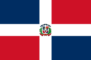
| National Colours | Blue, Red, White |
Cuisine
- Sancocho (a hearty stew)
- Mangu (mashed plantains)
- Arroz con Gandules (rice with pigeon peas)
Tourism Highlights
- Punta Cana (beaches and resorts)
- Puerto Plata (historical sites)
- Saraguaro National Park (nature and wildlife)
Natural Wonders
- Pico Duarte (highest peak in Hispaniola)
- Samaná Bay (coastal beauty)
Notable People
Juan Bosch, Pedro Miró
Fun Facts
- The Dominican Republic is the second-largest island nation in the Caribbean by area.
- It is one of the few countries in the Caribbean to have a significant, established industrial base outside of tourism.
Military
| Branches | Army, Navy, Air Force |
|---|---|
| Personnel (Approx.) | 71,000 |
International Relations
| UN Member Since | 1962 |
|---|---|
| Organizations | CARICOM |
| UNESCO Sites | 1 — Colonial City of Santo Domingo |
Infrastructure & Environment
| Driving Side | Right |
|---|---|
| Electrical | 110V, 60 Hz (A, B) |
| Internet Users | 91% |
| Mobile Subscriptions | 93.7 per 100 people |
| CO₂ Emissions | 34.2 Mt |
| Renewable Energy | 14.8% |
Environmental Issues
- Deforestation (historical)
- Coastal erosion
- Waste management
Communications
| International Calling Code | +1809, 829, 849 |
|---|---|
| Internet TLD | .do |
| Postal Code Format | ##### |
Emergency Services
External Links


 The EARF Engine