










Central America
Honduras
Republic of Honduras
"Free, Sovereign, and Independent"
Overview
Honduras, officially the Republic of Honduras, is a sovereign nation located in the Central American region of the Americas. It is geographically situated between Guatemala to the west, El Salvador to the southwest, and Nicaragua to the southeast. To the north, the country borders the large Gulf of Honduras, an inlet of the Caribbean Sea, while the Pacific Ocean defines its southern coast. The nation's capital and largest urban center is Tegucigalpa, which serves as the primary hub for its political and economic life.
Travel Advisory
Government & Politics
| Government Type | Unitary Presidential Republic |
|---|---|
| System | Republic |
| President | Nasry Asfura |
| President | Nasry Asfura |
| Legislature (Bicameral) | Congress of Honduras |
| Independence | 1980-03-07 from Guatemala |
| Constitution | 1982 |
Honduras is a unitary republic with a presidential system, where the President serves as both the head of state and head of government. The legislative power is vested in the bicameral Congress, composed of a House of Delegates and a Senate. The political landscape is often characterized by shifting alliances and a complex interplay between military, civil, and economic interests.
Honduras maintains close economic and diplomatic ties with the United States, which is a major source of foreign aid and trade. It is also a member of the Organization of American States (OAS) and participates in regional cooperation efforts with neighboring Central American nations, focusing on trade and security.
People, Language & Religion
| Official Languages | Spanish |
|---|---|
| Regional Languages | Miskito, Garifuna |
| Native Name SPA | Honduras |
| Demonym (Male) | Honduran |
| Ethnic — Miskito | Indigenous group primarily inhabiting the Caribbean coast. |
| Ethnic — Garifuna | Indigenous group descended from West African and Carib peoples, concentrated on the Caribbean coast. |
| Religion — Christianity | Predominantly Catholic, with significant Protestant and Evangelical Christian populations. |
Economy
| GDP (Nominal) | $39.6B USD |
|---|---|
| GDP (PPP) | $86.6B USD |
| GDP per Capita | $3,598 USD |
| GDP per Capita (PPP) | $7,871 USD |
| GDP Growth Rate | 3.8% |
| Gini Coefficient | 0.457 |
| Human Development Index 0.685 · Medium | |
| Unemployment Rate | 4.9% |
| Inflation Rate | 4.6% |
| Public Debt (% GDP) | 55% |
| Main Industries | Agriculture, Textiles, Services, Mining |
| Main Exports | Bananas, Coffee, Textiles, Gold |
| Main Imports | Fuel, Machinery, Consumer goods, Fertilizers |
| Export Partners | United States, Panama, Mexico |
| Import Partners | United States, Panama, Mexico |
| Currency | Honduran lempira (L) [HNL] |
Demographics
| Population | 11,005,850 |
|---|---|
| Urban Population | 59.3% |
| Median Age | 23 years |
| Life Expectancy | 73 years |
| Fertility Rate | 2.48 |
| Infant Mortality | 12.8 per 1,000 births |
| Literacy Rate | 88.3% |
Geography & Climate
The country's geography is diverse, encompassing mountainous spine running through the center, coastal plains, and significant Caribbean and Pacific inlets. The mountainous regions, such as the Contigua Range, are crucial for water resources and biodiversity. The Pacific coast is characterized by tropical beaches and low-lying land, while the Caribbean side features mangrove ecosystems and barrier islands.
| Terrain | Mountainous spine with coastal plains and tropical lowlands. |
|---|---|
| Total Area | 112,492 km² |
| Coastline | 1 km |
| Exclusive Economic Zone | 112,492 km² |
| Landlocked | No |
| Highest Point | Cerro de las Minas (2 m) |
| Lowest Point | Gulf of Fonseca (0 m) |
| Major Rivers | Ríoลำ (Riverลำ), Río Coco (Coco River) |
| Major Lakes | Lake Yojoba |
| Major Cities | Tegucigalpa, San Pedro Sula |
| Natural Resources | Gold, Silver, Copper, Agricultural land (coffee, bananas) |
| Climate | Tropical Savanna/Tropical Rainforest |
Honduras experiences a tropical climate, characterized by distinct wet and dry seasons. The Caribbean coast features tropical rainforests, while the interior and Pacific side exhibit tropical dry forest and savanna conditions, leading to high seasonal variability in rainfall.
History
Ancient & Early History
The region was historically inhabited by various indigenous groups, including the Lenca and Maya, who developed complex agricultural and social structures before the arrival of European explorers.
Colonial Period
Honduras was a key part of the Spanish colonial empire, initially administered as part of the Captaincy General of Guatemala. The region saw significant economic development through the cultivation of cacao and later, bananas, making it a strategic point in the transatlantic trade routes.
Independence
The country achieved formal independence from Spain in 1821, initially forming part of the Federal Republic of Central America. It later struggled with political instability and regional conflicts throughout the 19th and 20th centuries.
Modern Era
The 20th century was marked by periods of military rule and political upheaval. The country has undergone several constitutional changes and periods of democratic transition, often influenced by regional geopolitical dynamics and economic pressures.
Recent History
In recent decades, Honduras has focused on economic diversification, particularly in tourism and remittances. It continues to face challenges related to governance, infrastructure development, and combating transnational crime, while seeking integration into regional trade blocs.
Culture & National Symbols
Honduran culture is a vibrant blend of indigenous, African, and Spanish influences. The cuisine, particularly the staple 'baleadas,' reflects this fusion. The country's art and music are deeply tied to its coastal traditions and the history of the Caribbean trade.
| National Anthem | Honduras — "Honduras, tierra de gloria y de paz" |
|---|---|
| National Animal | Jaguar |
| National Bird | Keel-billed Toucan |
| National Flower | Hibiscus |
| National Sport | Baseball |
| National Dish | Baleadas |
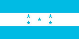
| National Colours | Blue, White, Blue |
Cuisine
- Baleadas (a popular street food consisting of tortillas, beans, cheese, and cream)
- Rice and Beans (Gallo Pinto style)
Tourism Highlights
- The Bay Islands (Islas Bayahibe) for Caribbean beach tourism.
- The Copán archaeological zone, known for its Mayan ruins.
- The natural reserves along the Caribbean coast.
Natural Wonders
- Gulf of Fonseca
- Bay Islands (Islas Bayahibe)
Notable People
Salvador Allende (Chilean President, associated with the region)
Fun Facts
- The country's motto, 'Libre, Soberana e Independiente,' emphasizes its historical struggle for autonomy.
- The Gulf of Fonseca is a unique geographical feature, serving as a meeting point for the Pacific and Caribbean oceans.
Military
| Branches | Army, Navy, Air Force |
|---|---|
| Personnel (Approx.) | 23,000 |
International Relations
| UN Member Since | 1980 |
|---|---|
| Organizations | OAS |
| UNESCO Sites | 0 |
Infrastructure & Environment
| Driving Side | Right |
|---|---|
| Electrical | 110V, 60 Hz (Type A, Type B) |
| Internet Users | 58.6% |
| Mobile Subscriptions | 70.9 per 100 people |
| CO₂ Emissions | 12.3 Mt |
| Renewable Energy | 45.9% |
Environmental Issues
- Deforestation and illegal logging, particularly in the mountainous regions.
- Coastal erosion and pollution from agricultural runoff.
- Vulnerability to hurricanes and climate change impacts.
Communications
| International Calling Code | +504 |
|---|---|
| Internet TLD | .hn |
| Postal Code Format | @@#### |
Emergency Services
External Links


 The EARF Engine