










Europe
Malta
Republic of Malta
"Truly Mediterranean"
Overview
The Republic of Malta is a sovereign island nation located in the central Mediterranean Sea, forming an archipelago between Sicily and North Africa. Its strategic location has historically made it a critical crossroads for trade and military power, attracting various empires from the Phoenicians and Romans to the Knights of St. John. With a population of approximately 525,000 inhabiting an area of 316 km², Malta is one of the world's most densely populated countries, often described as a city-state due to its compact urban nature. The country's culture is a unique blend of Mediterranean, British, and Arab influences, reflected in its official languages of Maltese and English.
Travel Advisory
Government & Politics
| Government Type | Republic |
|---|---|
| System | Parliamentary Republic |
| President | Myriam Spiteri Debono |
| Prime Minister | Robert Abela |
| Legislature (Bicameral) | Parliament of Malta |
| Independence | 1964-9-21 from United Kingdom (de facto) |
| Constitution | 1964 |
Malta is a parliamentary republic with a Westminster-style system, where the Prime Minister is the head of government and is drawn from the majority party in the Maltese Parliament. The government is formed by the party or coalition that commands the confidence of the legislature. The political landscape is generally characterized by a two-party system, though coalition governments are common.
Malta maintains strong diplomatic and economic ties with the European Union, Italy, and the United Kingdom. Its strategic location makes it a key partner in Mediterranean security and trade routes. It actively participates in regional cooperation efforts, particularly within the Mediterranean Dialogue.
People, Language & Religion
| Official Languages | Maltese, English |
|---|---|
| National Languages | Maltese |
| Native Name ENG | Malta |
| Native Name MLT | Malta |
| Demonym (Male) | Maltese |
| Ethnic — British | Significant minority |
| Ethnic — Italian | Minority |
| Ethnic — Maltese | Majority |
| Religion — Islam | Small minority |
| Religion — Catholicism | Majority |
| Religion — Protestantism | Minority |
Economy
| GDP (Nominal) | $27.8B USD |
|---|---|
| GDP (PPP) | $41.9B USD |
| GDP per Capita | $47,907 USD |
| GDP per Capita (PPP) | $72,210 USD |
| GDP Growth Rate | 2.5% |
| Gini Coefficient | 0.318 |
| Human Development Index 0.93 · Very High | |
| Unemployment Rate | 2.9% |
| Inflation Rate | 2.4% |
| Public Debt (% GDP) | 30% |
| Main Industries | Financial Services, Tourism, Maritime Services, Gaming |
| Main Exports | Services (Financial/IT), Pharmaceuticals, Processed Goods |
| Main Imports | Energy, Foodstuffs, Machinery |
| Export Partners | Germany, United Kingdom, Italy |
| Import Partners | Italy, Germany, France |
| Currency | Euro (€) [EUR] |
Demographics
| Population | 579,704 |
|---|---|
| Urban Population | 95.7% |
| Median Age | 35 years |
| Life Expectancy | 83 years |
| Fertility Rate | 1.01 |
| Infant Mortality | 4.7 per 1,000 births |
| Literacy Rate | 99.5% |
Geography & Climate
The Maltese archipelago is situated in the central Mediterranean, comprising several islands, the largest being Malta itself. Its geography is characterized by a mix of limestone plateaus, coastal cliffs, and deep harbors. The islands are strategically positioned between the major continental landmasses of Italy and North Africa, giving them a unique maritime history. The terrain is generally rugged, with limited arable land, which has historically influenced its reliance on maritime trade.
| Terrain | Limestone plateaus, coastal cliffs, and deep harbors |
|---|---|
| Total Area | 316 km² |
| Coastline | 360 km |
| Exclusive Economic Zone | 12,000 km² |
| Landlocked | No |
| Highest Point | Monte Sirsa (190 m) |
| Lowest Point | Mediterranean Sea (0 m) |
| Major Rivers | None (seasonal runoff) |
| Major Cities | Valletta, Sliema, Żejtun |
| Natural Resources | Limestone, Salt, Marine resources |
| Climate | Mediterranean |
Malta experiences a classic Mediterranean climate, characterized by hot, dry summers and mild, wet winters. The temperature variation is moderate, and rainfall is concentrated in the cooler months. Coastal areas benefit from maritime influences, moderating the extreme seasonal temperature shifts.
History
Ancient & Early History
The islands have been inhabited since the Neolithic period, with evidence of early farming and settlement. They were later colonized by the Phoenicians, who established trading posts, and subsequently by the Romans, who integrated them into the Roman Empire's Mediterranean network.
Colonial Period
Malta was a key strategic point, leading to successive occupations by various powers. It was under the control of the Byzantine Empire, the Arab Caliphate, the Norman Kingdom, and most famously, the Knights Hospitaller of St. John, who governed the islands from 1530 to 1798.
Independence
Following the French occupation in 1798, the islands were returned to British control. Malta achieved internal self-governance and full independence from the United Kingdom on September 21, 1964.
Modern Era
Since independence, Malta has undergone significant economic diversification, leveraging its strategic location and skilled workforce. It has become a major hub for international finance, maritime services, and technology, while maintaining strong cultural ties to its Mediterranean heritage.
Recent History
The country has been a member of the European Union's associated partners, facilitating deep economic integration. Recent decades have seen rapid infrastructure development and a focus on sustainable tourism and digital economy growth, solidifying its role in the Mediterranean economy.
Culture & National Symbols
Malta boasts a rich cultural tapestry, evident in its unique blend of architectural styles, particularly the Baroque architecture of Valletta. The culture is deeply intertwined with the sea, reflected in its maritime traditions and cuisine. The island's history has fostered a unique syncretism of Mediterranean, Latin, and British influences.
| National Anthem | Malta — "Malta, l-art minnija, l-għażżel ta' l-belt" |
|---|---|
| National Animal | Dog |
| National Bird | Seagull |
| National Flower | Bougainvillea |
| National Tree | Mediterranean Pine |
| National Sport | Football (Soccer) |
| National Dish | Pastizzi |
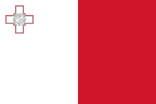
| National Colours | White, Red |
Cuisine
- Pastizzi (flaky pastry filled with ricotta or mushy peas)
- Lampukija (a traditional Maltese stew)
- Rotajet (a type of bread)
Tourism Highlights
- Valletta's UNESCO World Heritage Site status and Baroque architecture
- The Blue Lagoon (marine swimming area)
- The prehistoric temples of Ħaġar Qim and Mnajdra
Natural Wonders
- The Blue Lagoon
- The Maltese coastline's dramatic cliffs
Notable People
George Vella, Emile Daphne, Sir Staunton Shaw
Fun Facts
- Malta is one of the world's most densely populated countries.
- The Maltese language is a Semitic language, written in the Latin alphabet, making it unique in the Mediterranean.
Military
| Branches | Army, Navy, Air Force |
|---|---|
| Personnel (Approx.) | 2,000 |
International Relations
| UN Member Since | 1962 |
|---|---|
| Organizations | European Union (Associate), Commonwealth of Nations |
| UNESCO Sites | 1 — Valletta |
Infrastructure & Environment
| Driving Side | Right |
|---|---|
| Electrical | 230V, 50 Hz (Type C, Type F) |
| Internet Users | 93.9% |
| Mobile Subscriptions | 142.1 per 100 people |
| CO₂ Emissions | 1.8 Mt |
| Renewable Energy | 8.6% |
Environmental Issues
- Coastal erosion and sea-level rise
- Waste management and pollution in confined urban spaces
Communications
| International Calling Code | +356 |
|---|---|
| Internet TLD | .mt |
| Postal Code Format | @@@ ###|@@@ ## |
Emergency Services
External Links



 The EARF Engine