










Africa
Mauritius
Republic of Mauritius
"Star and Key of the Indian Ocean"
Overview
Mauritius, officially the Republic of Mauritius, is a sovereign island nation located in the Indian Ocean, situated approximately 2,000 kilometers off the southeastern coast of East Africa, east of Madagascar. The country comprises the main island, along with smaller dependencies such as Rodrigues and Agaléga. Its strategic location has historically made it a crucial point in global trade routes. The nation boasts a diverse blend of cultures and economies, maintaining a reputation for stability and tourism. The capital and largest city is Port Louis, which serves as the primary economic and administrative hub.
Travel Advisory
Government & Politics
| Government Type | Parliamentary Republic |
|---|---|
| System | Republic |
| President | Dharam Gokhool |
| Prime Minister | Navin Ramgoolam |
| Legislature (Unicameral) | National Assembly |
| Independence | 1968-10-12 from United Kingdom |
| Constitution | 1968 |
Mauritius operates as a parliamentary republic with a Westminster-style democracy. The government is led by a Prime Minister, who is drawn from the majority party in the National Assembly. The political landscape is characterized by a multi-ethnic coalition of parties, reflecting the island's diverse population. The constitution guarantees fundamental rights and promotes democratic participation.
Mauritius maintains strong diplomatic and economic ties with its former colonial power, the United Kingdom, as well as with major global economies like India, China, and France. It is an active member of the Commonwealth and the Indian Ocean Rim Association, focusing on regional cooperation and maritime security.
People, Language & Religion
| Official Languages | English |
|---|---|
| National Languages | Mauritian Creole |
| Regional Languages | French |
| Native Name ENG | Mauritius |
| Native Name FRA | Maurice |
| Native Name MFE | Moris |
| Demonym (Male) | Mauritian |
| Ethnic — Creole | 30% |
| Ethnic — Indian | 40% |
| Ethnic — African | 20% |
| Ethnic — European | 10% |
| Religion — Islam | 20% |
| Religion — Hinduism | 15% |
| Religion — Christianity | 25% |
Economy
| GDP (Nominal) | $16.2B USD |
|---|---|
| GDP (PPP) | $41.9B USD |
| GDP per Capita | $12,991 USD |
| GDP per Capita (PPP) | $33,667 USD |
| GDP Growth Rate | 5.2% |
| Gini Coefficient | 0.368 |
| Human Development Index 0.805 · Very High | |
| Unemployment Rate | 5.6% |
| Inflation Rate | 3.7% |
| Public Debt (% GDP) | 57.1% |
| Main Industries | Tourism, Financial Services, Textiles, Agriculture |
| Main Exports | Sugar, Textiles, Spices, Fish products |
| Main Imports | Fuel, Machinery, Foodstuffs, Consumer goods |
| Export Partners | India, China, France |
| Import Partners | China, India, South Africa |
| Currency | Mauritian rupee (₨) [MUR] |
Demographics
| Population | 1,243,741 |
|---|---|
| Urban Population | 39% |
| Median Age | 28 years |
| Life Expectancy | 73.8 years |
| Fertility Rate | 1.44 |
| Infant Mortality | 13.8 per 1,000 births |
| Literacy Rate | 98% |
Geography & Climate
The island nation is situated in the Mascarene Plateau, in the Indian Ocean. Its geography is characterized by a mix of volcanic origins and coral formations. The main island is relatively small but highly fertile, supporting diverse ecosystems. The country's location makes it a critical maritime hub, with extensive coastlines and a vast exclusive economic zone.
| Terrain | Volcanic, coastal, and tropical plains |
|---|---|
| Total Area | 2,040 km² |
| Coastline | 55 km |
| Exclusive Economic Zone | 2,300,000 km² |
| Landlocked | No |
| Highest Point | Piton de la Rivière Noire (121 m) |
| Lowest Point | Coastal areas (0 m) |
| Major Rivers | Rivière Rivière Noire |
| Major Cities | Port Louis, Vacoos, Black River |
| Natural Resources | Tourism, Sugarcane, Marine resources |
| Climate | Tropical Rainforest/Tropical Monsoon |
Mauritius experiences a tropical maritime climate, characterized by high temperatures and humidity year-round. The climate is moderated by the surrounding Indian Ocean, resulting in relatively mild seasonal variations. The wet season typically runs from May to September, bringing heavy rainfall, while the dry season is generally from December to April.
History
Ancient & Early History
The island has been inhabited by various groups over millennia, with evidence of early human settlement dating back thousands of years. Historically, it was a key stop on the Indian Ocean trade routes, attracting traders and colonizers from Arabia, India, and Europe.
Colonial Period
Mauritius was first encountered by European explorers, notably the French and British. It was later established as a major sugar plantation colony, primarily under British rule. The colonial period saw the introduction of indentured laborers, predominantly from India, which fundamentally shaped the island's demographic and cultural makeup.
Independence
The path to independence was gradual, involving negotiations with the British colonial administration. Mauritius achieved full independence on October 12, 1968, after a period of self-governance.
Modern Era
Post-independence, Mauritius successfully diversified its economy away from sugar, establishing itself as a regional financial and service hub. The country has maintained a reputation for political stability and democratic governance, attracting foreign investment and skilled labor.
Recent History
In recent decades, the nation has focused on sustainable development, leveraging its pristine environment and stable political climate for high-end tourism and international business services. It continues to navigate the challenges of climate change while promoting its multicultural identity.
Culture & National Symbols
The culture is a unique blend of Indian, African, and European influences, resulting in a vibrant Creole identity. Festivals, cuisine, and music reflect this syncretic heritage. The island is renowned for its natural beauty, including lush tropical landscapes and pristine beaches.
| National Anthem | L'hymne de Maurice — "Oh, Maurice, terre de lumière" |
|---|---|
| National Animal | None officially designated |
| National Bird | None officially designated |
| National Flower | Frangipani |
| National Tree | Coconut Palm |
| National Sport | Cricket |
| National Dish | Dholl Puri |
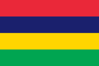
| National Colours | Blue, Yellow, Red |
Cuisine
- Dholl Puri (a local flatbread)
- Curry-infused dishes
- Fresh seafood preparations
Tourism Highlights
- Beaches and snorkeling in the Indian Ocean
- Luxury resorts and spas
- Nature reserves and hiking trails
Natural Wonders
- Black River Gorge
- Le Morne Brabant (UNESCO World Heritage Site)
Notable People
Sir Seewoosagur Ramgoolam (First Prime Minister)
Fun Facts
- The island is part of the Mascarene Islands group.
- It is known for its high level of political stability in the Indian Ocean region.
Military
| Branches | Army, Navy, Air Force |
|---|---|
| Personnel (Approx.) | 3,000 |
International Relations
| UN Member Since | 1968 |
|---|---|
| Organizations | Commonwealth of Nations |
| UNESCO Sites | 0 |
Infrastructure & Environment
| Driving Side | Left |
|---|---|
| Electrical | 230V, 50 Hz (Type D) |
| Internet Users | 73.3% |
| Mobile Subscriptions | 172.7 per 100 people |
| CO₂ Emissions | 4.4 Mt |
| Renewable Energy | 8.6% |
Environmental Issues
- Coastal erosion due to rising sea levels
- Waste management and plastic pollution
Communications
| International Calling Code | +230 |
|---|---|
| Internet TLD | .mu |
Emergency Services
External Links


 The EARF Engine