










Oceania
New Caledonia
"Get Closer to What You Love"
Overview
New Caledonia is a French overseas collectivity located in the southwest Pacific Ocean, situated approximately 220 km southwest of Vanuatu and 1,210 km east of Australia. It is a Melanesian island group, characterized by a unique legal status within the French Republic. The territory is known for its stunning natural beauty, including rich biodiversity and dramatic volcanic landscapes. The population is estimated at around 272,000 people, with the main urban center being Nouméa. Its economy is historically tied to nickel mining, though it is diversifying into tourism and agriculture.
Travel Advisory
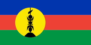
Government & Politics
| Government Type | Overseas Collectivity (Collectivité territoriale) |
|---|---|
| System | Unitary Republic (French Decentralization) |
| President of the French Republic | High Commissioner of French Polynesia |
| President of the Council (Prime Minister) | Gabriel Attal |
| Legislature (Unicameral) | Assembly of New Caledonia (Assemblée de Nouvelle-Calédonie) |
New Caledonia is an overseas collectivity of France, meaning it is legally and constitutionally part of the French Republic. It possesses a high degree of local self-governance, managing its own local affairs, economy, and public services. The political structure is complex, balancing French central authority with local Kanak political aspirations for greater autonomy or even independence.
Its foreign relations are primarily managed through France, which acts as its representative on the international stage. However, due to its geographical location and Melanesian culture, it maintains strong cultural and economic ties with neighboring Pacific Island nations, including Vanuatu and Fiji, while also engaging with major global partners like Australia and China for trade and investment.
People, Language & Religion
| Official Languages | French |
|---|---|
| Regional Languages | Kanak languages (e.g., Drehuale, Drehuale-Kanak) |
| Native Name FRA | Nouvelle-Calédonie |
| Demonym (Male) | New Caledonian |
| Ethnic — Asian | Various Pacific Islander groups |
| Ethnic — Kanak | Indigenous Melanesian population |
| Ethnic — European | French settlers and expatriates |
| Religion — Christianity | Predominant (Catholicism, Protestantism) |
| Religion — Indigenous Beliefs | Practiced by Kanak population |
Economy
| GDP (Nominal) | $8.5B USD |
|---|---|
| GDP (PPP) | $6.5B USD |
| GDP per Capita | $29,213 USD |
| GDP Growth Rate | 2.5% |
| Gini Coefficient | 0.3 |
| Human Development Index 0.8 · High | |
| Unemployment Rate | 11.2% |
| Inflation Rate | 0.6% |
| Public Debt (% GDP) | 45% |
| Main Industries | Mining (Nickel, Cobalt), Tourism, Agriculture (Copra, Vanilla, Cocoa), Fishing |
| Main Exports | Nickel ore, Cobalt, Copra, Vanilla, Coconuts |
| Main Imports | Fuel and energy products, Manufactured goods, Foodstuffs, Machinery |
| Export Partners | France, Australia, China |
| Import Partners | France, Australia |
| Currency | CFP franc (₣) [XPF] |
Demographics
| Population | 295,333 |
|---|---|
| Urban Population | 68.2% |
| Median Age | 28 years |
| Life Expectancy | 78.9 years |
| Fertility Rate | 1.96 |
| Infant Mortality | 12 per 1,000 births |
| Literacy Rate | 98% |
Geography & Climate
The territory comprises several islands, including the main island of Grande Terre, which is characterized by rugged, mountainous terrain and deep river valleys. The geography is defined by volcanic activity and coral reef formations, creating a diverse coastal environment. The southwest corner of the main island features some of the region's most pristine and biodiverse areas, making it a significant ecological zone.
| Terrain | Volcanic, mountainous, and coral reef dominated |
|---|---|
| Total Area | 18,575 km² |
| Coastline | 1,500 km |
| Exclusive Economic Zone | 1,200,000 km² |
| Landlocked | No |
| Highest Point | Mont Issara (1,700 m) |
| Lowest Point | Coastal areas/Reefs (0 m) |
| Major Rivers | River Koura, River Bara |
| Major Lakes | Lac de la Bara |
| Major Cities | Nouméa, Port Vila (Vanuatu - nearby reference), South Province centers |
| Natural Resources | Nickel (major export), Cobalt, Chromium, Phosphate, Tropical timber |
| Climate | Tropical Monsoon (Am) |
New Caledonia experiences a tropical monsoon climate, characterized by distinct wet and dry seasons. The climate is influenced by the trade winds and the proximity to the Pacific Ocean, resulting in high humidity and consistent rainfall, particularly during the wet season (November to April). Temperatures are consistently warm year-round.
History
Ancient & Early History
The region has been inhabited by Melanesian peoples for millennia, with archaeological evidence suggesting continuous occupation dating back thousands of years. Early cultures were highly adapted to the tropical island environment, developing sophisticated subsistence methods based on fishing and horticulture.
Colonial Period
New Caledonia was first encountered by Europeans in the 17th century and was gradually claimed by various powers, including France and Britain. France established a significant presence, particularly after the mid-19th century, leading to intensive resource exploitation, especially of nickel. The territory was administered as a French colony until the mid-20th century.
Independence
The territory has not achieved full political independence. It maintains a unique constitutional status as an overseas collectivity of the French Republic, granting it a high degree of local autonomy while remaining legally part of France.
Modern Era
Following World War II, the French administration solidified its control, integrating the local population into the French legal and economic framework. The discovery and exploitation of vast nickel reserves transformed the local economy, making it a global industrial hub. This period saw increasing political and cultural movements advocating for greater self-determination.
Recent History
In recent decades, the political landscape has been marked by debates over autonomy and self-governance, often involving the Kanak population. The government has worked to balance economic development, particularly in mining, with environmental protection and cultural recognition, leading to complex constitutional negotiations.
Culture & National Symbols
The culture is a rich syncretism of Melanesian traditions and French colonial influences. Traditional Kanak arts, including intricate carvings and ceremonial dances, coexist with modern French cultural practices. The local cuisine and festivals often blend these two distinct heritage streams, creating a unique Pacific identity.
| National Anthem | L'Hymne de la Nouvelle-Calédonie — "Ô Nouvelle-Calédonie, terre de nos ancêtres" |
|---|---|
| National Sport | Rugby |
| National Dish | Poisson cru (Raw fish) |
| National Colours | Blue, Yellow, Red |
Cuisine
- Poisson cru (Raw fish, often marinated in coconut milk and lime)
- Taro and Yam stews
- Copra bread
Tourism Highlights
- The stunning turquoise lagoons and coral reefs
- The pristine beaches and tropical rainforests
- The unique blend of Melanesian culture and French amenities
Natural Wonders
- The Loyalty Islands archipelago
- The vast coral reef systems
- The volcanic peaks of Grande Terre
Notable People
Jean-Marie Tjilatiero (Kanak activist), Various local political leaders
Fun Facts
- New Caledonia is one of the world's largest producers of nickel ore.
- It is a French overseas collectivity, meaning it is not an independent nation.
- The local currency is the CFP franc (XPF).
Military
| Branches | French Armed Forces (Deployed personnel), Local Police Forces |
|---|---|
| Personnel (Approx.) | 1,500 |
International Relations
| UN Member Since | 1988 |
|---|---|
| Organizations | Pacific Islands Forum (PIF) |
| UNESCO Sites | 1 — Bougainville Island (Potential/Regional) |
Infrastructure & Environment
| Driving Side | Left |
|---|---|
| Electrical | 230V, 50 Hz (Type E, Type F) |
| Internet Users | 82% |
| Mobile Subscriptions | 91.7 per 100 people |
| CO₂ Emissions | 5 Mt |
| Renewable Energy | 9.6% |
Environmental Issues
- Mining impacts (Nickel runoff and habitat destruction)
- Climate change vulnerability (Sea-level rise, extreme weather)
- Biodiversity conservation (Protecting endemic species)
Communications
| International Calling Code | +687 |
|---|---|
| Internet TLD | .nc |
| Postal Code Format | ##### |
Emergency Services
External Links


 The EARF Engine