










Central America
Panama
Republic of Panama
"For the Benefit of the World"
Overview
The Republic of Panama is a sovereign nation located in the isthmus connecting North and South America, placing it at the southern tip of Central America. It is bordered by Costa Rica to the west and Colombia to the southeast, with the Caribbean Sea to the north and the Pacific Ocean to the south. The country is renowned for the Panama Canal, a critical global shipping route, and its diverse geography, which includes tropical rainforests, mountainous spine, and extensive coastlines. Panama City serves as the capital and largest urban center, serving as a major hub for international finance and trade.
Travel Advisory
Government & Politics
| Government Type | Unitary Presidential Republic |
|---|---|
| System | Republic |
| President | José Raúl Mulino |
| President | José Raúl Mulino |
| Legislature (Unicameral) | National Assembly |
| Independence | 1903-11-3 from Colombia |
| Constitution | 1972 |
Panama operates as a unitary presidential republic with a democratic framework. Its political stability is closely tied to its economic success, particularly in finance and logistics. The country has historically balanced its relationship between its powerful neighbors, Colombia and Costa Rica, while leveraging its unique geographic position.
Panama maintains strong economic and diplomatic ties with the United States, which remains a key trade partner and historical influence. It also has growing trade relationships with China and regional partners in Latin America, positioning itself as a key player in Central American trade routes.
People, Language & Religion
| Official Languages | Spanish |
|---|---|
| Regional Languages | English |
| Native Name SPA | Panamá |
| Demonym (Male) | Panamanian |
| Ethnic — Indigenous | Small percentage |
| Ethnic — Panamanian | Majority |
| Ethnic — Afro-Caribbean | Significant minority |
| Religion — Catholicism | Significant portion |
| Religion — Christianity | Majority |
| Religion — Protestantism | Minority |
Economy
| GDP (Nominal) | $90.5B USD |
|---|---|
| GDP (PPP) | $200.7B USD |
| GDP per Capita | $19,790 USD |
| GDP per Capita (PPP) | $43,902 USD |
| GDP Growth Rate | 4.5% |
| Gini Coefficient | 0.497 |
| Human Development Index 0.755 · High | |
| Unemployment Rate | 8.4% |
| Inflation Rate | -0.2% |
| Public Debt (% GDP) | 45% |
| Main Industries | Services (Finance, Tourism), Canal Operations, Agriculture, Mining |
| Main Exports | Bananas, Gold, Nickel, Services (Canal), Manufactured goods |
| Main Imports | Fuel oil, Machinery, Consumer goods, Chemicals |
| Export Partners | United States, China, Mexico |
| Import Partners | United States, China, Colombia |
| Currency | Panamanian balboa (B/.) [PAB], United States dollar ($) [USD] |
Demographics
| Population | 4,571,189 |
|---|---|
| Urban Population | 66.2% |
| Median Age | 28 years |
| Life Expectancy | 79.8 years |
| Fertility Rate | 2.11 |
| Infant Mortality | 12 per 1,000 births |
| Literacy Rate | 96.2% |
Geography & Climate
The country is an isthmus connecting the continents of North and South America. Its geography is highly varied, featuring the mountainous spine of the Cordillera Central, which runs through the country, and extensive coastal plains. The narrow width of the isthmus, combined with the Caribbean and Pacific access, has historically made it a critical global transit point.
| Terrain | Mountainous spine running through tropical coastal plains |
|---|---|
| Total Area | 756 km² |
| Coastline | 1 km |
| Exclusive Economic Zone | 1,000,000 km² |
| Landlocked | No |
| Highest Point | Volcán Barú (2 m) |
| Lowest Point | Caribbean Sea/Pacific Ocean (0 m) |
| Major Rivers | Chagres River, Tuuca River |
| Major Lakes | Lake Gatun |
| Major Cities | Panama City, Colón, David |
| Natural Resources | Gold, Copper, Oil, Tropical timber, Agricultural products (bananas, mangoes) |
| Climate | Tropical Rainforest/Tropical Savanna |
Panama experiences a tropical wet and dry climate, characterized by distinct wet and dry seasons. The Caribbean coast receives high rainfall year-round, supporting dense rainforests, while the Pacific side experiences a more pronounced dry season, though both are generally tropical.
History
Ancient & Early History
The region was inhabited by various indigenous groups, including the Kuna (Guna) people, who maintained distinct cultures and territories. Archaeological evidence points to early settlements along the coasts, predating European contact by millennia.
Colonial Period
Panama was claimed by Spain in the 16th century and became a crucial strategic outpost due to its location. It was governed by various colonial powers, including the British and Americans, who exploited its strategic value, particularly for the development of the canal.
Independence
Panama achieved de facto independence from Colombia in 1903, a process heavily influenced by American interests, which subsequently led to the construction and control of the Panama Canal.
Modern Era
The country underwent significant political instability in the mid-20th century. Its modern identity is inextricably linked to the canal, which was eventually transferred back to Panamanian control in the late 20th century, solidifying its sovereignty and economic role.
Recent History
The 21st century has seen Panama solidify its role as a major financial and logistical hub. The successful transition of the Panama Canal and the development of its surrounding infrastructure have boosted its economy and international profile.
Culture & National Symbols
Panamanian culture is a vibrant blend of indigenous, African, and European influences. The cuisine, music, and festivals reflect this melting pot, while the architecture in Panama City showcases a mix of colonial Spanish and modern international styles.
| National Anthem | Panamá — "Panamá, tierra de sol y mar" |
|---|---|
| National Animal | Jaguar |
| National Bird | Keel-billed Toucan |
| National Flower | Hibiscus |
| National Tree | Mango |
| National Sport | Football (Soccer) |
| National Dish | Sancocho de gallina |
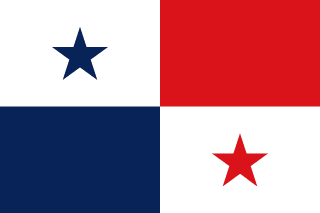
| National Colours | Red, Blue, White |
Cuisine
- Sancocho de gallina (Chicken stew)
- Arroz con coco (Coconut rice)
- Patacones (Fried plantain chunks)
Tourism Highlights
- The Panama Canal (Engineering marvel)
- Bocas del Toro (Caribbean island getaway)
- San Blas Islands (Indigenous paradise)
- Tayrona National Park (Biodiversity)
Natural Wonders
- The Panama Canal
- Bocas del Toro Archipelago
- Darién Gap
Notable People
Omar Torrijos Herrera, Ricardo Mariadiscus
Fun Facts
- The Panama Canal is one of the most significant feats of 20th-century engineering.
- The country's motto, 'Pro Mundi Beneficio,' reflects its historical role in global trade.
Military
| Branches | Army, Navy, Air Force |
|---|---|
| Personnel (Approx.) | 28,000 |
International Relations
| UN Member Since | 1946 |
|---|---|
| Organizations | OAS, WTO |
| UNESCO Sites | 1 — Panama Canal |
Infrastructure & Environment
| Driving Side | Right |
|---|---|
| Electrical | 110V, 60 Hz (A, B) |
| Internet Users | 72.8% |
| Mobile Subscriptions | 156.6 per 100 people |
| CO₂ Emissions | 12.4 Mt |
| Renewable Energy | 28% |
Environmental Issues
- Deforestation in the Darién Gap
- Coastal pollution from shipping
- Impact of climate change on coral reefs
Communications
| International Calling Code | +507 |
|---|---|
| Internet TLD | .pa |
Emergency Services
External Links


 The EARF Engine